08 April 2020
Speed and Altitude in Aviation, and Why Using a Phone’s Barometer and GPS in Flight is (Almost) Useless
…
The main flight characteristics of an aircraft are speed and altitude.
Every modern phone can calculate both values fairly accurately using its built-in barometer and GPS receiver.
But if pilots lose access to these instruments, why wouldn’t the phone help them?
Let’s ask two introductory questions.
Question 1. Speed is correct, but altitude is not?
Suppose we took off in a Boeing 737, reached cruising altitude, and the “Fasten Seatbelt” sign went out.
We take out the phone, launch a car navigator — and we see a solid 700–900 km/h depending on heading and phase of flight:
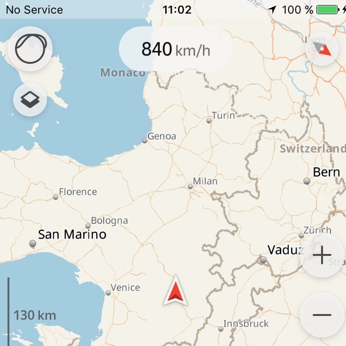
Now we open the barometer and see an altitude reading of about 1.5–2.4 km.
What’s with the altitude is an interesting matter, but before that, let’s ask the second question.
Question 2. Why do airplanes crash due to incorrect speed readings if the speed on the phone is correct?
The most common cause of aviation accidents (including fatal crashes) is loss of control in flight, abbreviated LOC-I (Loss of Control in Flight).
Loss of control does not always mean a malfunction of the aircraft itself — the fuselage can be intact, the control surfaces and engines perfectly serviceable. Often this means that pilots lost a technically sound aircraft in flight because instruments stopped giving correct readings.
A considerable number of air crashes have happened because of incorrect speed readings, even in times when cabins were packed with a hundred or two passengers carrying phones in their pockets. And we just verified that GPS speed on a phone, unlike pressure-based altitude, is correct. So why couldn’t pilots just check their phones?
Because what we see is ground speed. It’s good for calculating arrival times, but absolutely useless for piloting.
Why is ground speed useless?
Because what we really need is airspeed — the speed of airflow relative to the aircraft.
An airplane can only fly safely within two limits — the speed must be high enough for the wings to generate enough lift, and low enough that the airflow doesn’t tear the wings or other structures apart.
This means the aircraft has two critical speeds: minimum (stall speed) and maximum (structural limit).
The aircraft does not fly relative to the earth (as GPS measures), but within the surrounding air mass. More precisely, lift is generated by the wing moving through the air. If the plane is too slow, there isn’t enough lift to stay aloft. If it’s too fast, the airflow begins to bend and tear structural parts.
So, to keep the aircraft within safe limits, we need airspeed — not ground speed.
More accurately, there are three different speeds used in piloting:
Definitions:
- Indicated Airspeed or IAS — the speed of the oncoming airflow, measured by Pitot tubes. This is the primary speed for flying because lift and structural stresses depend directly on it.
- True Airspeed or TAS — the speed of the aircraft relative to the air mass, corrected for temperature and atmospheric pressure at current altitude (ALT). Calculated as IAS + (IAS * 0.02 * ALT/1000).
- Ground Speed or GS — the speed of the aircraft relative to the ground.
So, if the pilots’ instruments are giving strange readings and you don’t have the option of sticking a Pitot tube out of the window at –50° while flying 800 km/h, your phone won’t help them.
Now, about sticking the phone outside. Let’s return to the barometer.
Suppose all altitude instruments failed and we want to help pilots using our phone. Suppose also that it gives us the “real” reading and not “weather.”
Why do we need altitude in flight anyway?
For example, altitude (flight level) is used to separate aircraft. Planes flying westward use odd flight levels, and those going eastward — even ones. Mid-air collisions are not recommended by the Ministry of Health.
Or, in case of total engine failure, altitude allows the aircraft to glide over a certain distance depending on its glide ratio. With a 737’s glide ratio of 15, for every 1 meter of altitude you can glide forward 15 meters. From 10 km up, that gives you 150 km range — often enough to make it to an airfield.
But we already saw the barometer showing 2 km when we’re actually at 10 km.
It’s because of how pressure is measured and how airliners are pressurized. The higher the altitude, the thinner the air, and the less oxygen it contains. Up to 1500 m, there’s enough oxygen for humans, but above that hypoxia begins and can lead to unconsciousness. Clearly, passengers can’t be subjected to cabin pressure corresponding to 10,000 m altitude — unless the airline really wants to save money on chicken or fish service.
Thus, the aircraft cabin is pressurized, typically to the equivalent of about 2.4 km altitude, though it varies between aircraft. The modern Dreamliner or A350 XWB (Airbus could’ve thought of a nicer name) maintains about 1800–1900 m thanks to composite materials that withstand higher pressure. Older all-metal planes like the 737 and A320 pressurize to around 2.4 km, which is why long-haul flights can leave you feeling like you’re at mild high altitude.
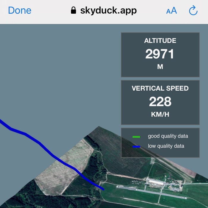
So, your phone barometer only measures cabin altitude, not real altitude. To measure actual altitude outside, you’d need to expose the phone to the –50° outside air, which isn’t convenient. Though, as demonstrated by my friends Vlad Dugnist and Igor Kamenev from Skyduck APP, who measure skydiver altitudes — it does work:
In summary: many more variables matter in flight than in everyday phone use. You can use a phone to check your location and rough ground speed, or to guess why your legs went numb and you felt off during a long-haul flight. But for actual flight data — it’s useless.
Thanks to Denis Okan for the interest in the subject and to Igor Malukhin for his book “737. My First Liner”, which provided important details on speed and pressurization.